
Visual Abstraction and Stylisation of Maps
Abstract
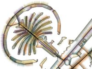
We explore visual map abstraction for the generation of stylized renderings of 2D map data. We employ techniques that are centered around the concept of shape simplification and graph layout and that allow iterative abstraction of 2D maps. We use data from publicly available sources and show how we can iteratively generate aesthetic renditions of these maps. These renditions do not have the goal to allow for navigation tasks but instead show the map data in a distorted manner. The techniques used to create these images apply simplification, abstraction/generalization, and displacement operations to the map elements in varying orders and add stylistic shading to produce aesthetic renditions for print or electronic displays. The degree of abstraction/generalization can be individually chosen and determines the characteristics of the distorted map: whether components retain their shape, degenerate, or are processed in a manner that the abstraction becomes the focus of the image rather than the underlying map data. The renditions can be further personalized by choosing shading and colors for this shading. Together, the presented techniques allow for playful and creative exploration of aesthetic renditions of 2D map data.
Domains
Graphics [cs.GR]
Fichier principal
 Isenberg_2013_VAS.pdf (2.74 Mo)
Télécharger le fichier
Isenberg_2013_VAS.pdf (2.74 Mo)
Télécharger le fichier
 Isenberg_2013_VAS.jpg (10.63 Ko)
Télécharger le fichier
Isenberg_2013_VAS.jpg (10.63 Ko)
Télécharger le fichier
Origin : Files produced by the author(s)
Format : Figure, Image
Loading...